Reston Scar and Brunt Knott Trail Running Route: 13km Lake District Loop
A 12.6km circular trail running route from Staveley village centre / Mill Yard area linking the outlying fells above Staveley with open fell views across the South Lakes
12.6km
Distance
694m
Elevation Gain
2.4 hours to 3.1 hours running / 4.2 to 5.2 hours walking
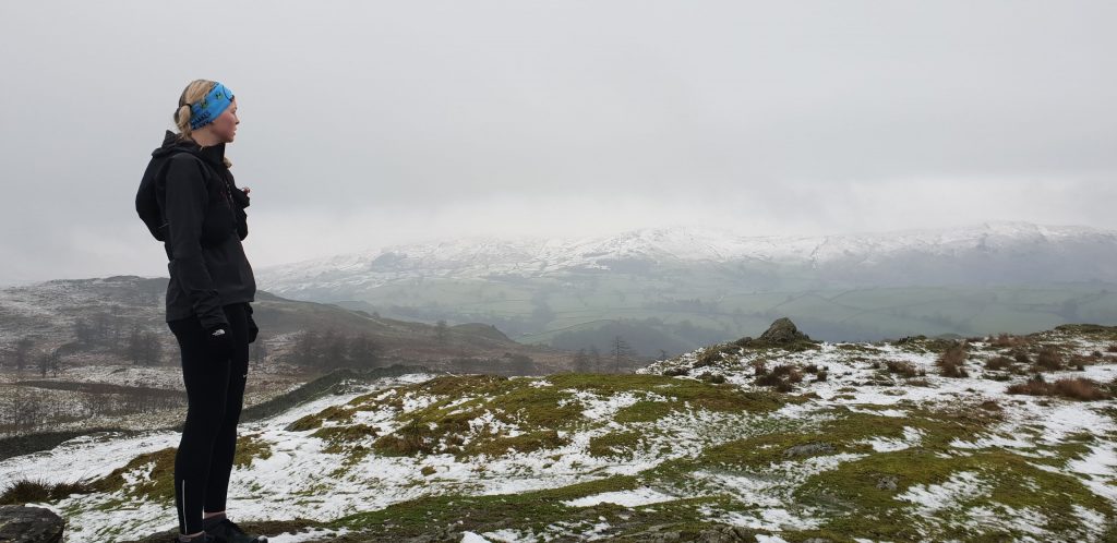
This Reston Scar and Brunt Knott trail running route is a circular loop from Staveley village centre / Mill Yard area, built from the supplied GPX file and suitable for runners who are comfortable on mixed trail terrain.
The GPX measures approximately 12.6km with around 694m of elevation gain and reaches a highest point of about 446m. It is a punchy South Lakes loop rather than a high mountain route, but the climbing comes steadily and the open fell sections feel surprisingly wild for a route starting so close to Staveley village.
Use the GPX for navigation, carry appropriate kit for the distance and weather, and always check local access, parking and public transport details before travelling.
Route Features
At a Glance
📍 Start:Staveley
Getting there
Start Point
Staveley
LA8 9LR
Parking
Use public parking in Staveley village or the Mill Yard area where permitted. Parking can be busy at weekends, so arrive early and check local signs and payment requirements before leaving your vehicle.
Public Transport
Staveley has a railway station on the Windermere branch line, with services linking Windermere and Oxenholme/Lancaster connections. Local bus options vary by season, so check current timetables before travelling.
Toilets
Public toilet availability in Staveley can change; check Staveley village facilities before setting off. Cafes and pubs may be available for customers.
Nearest Town
Staveley
what3words
What's underfoot
Expect village lanes, fell paths, open fell, farm tracks, woodland paths, moorland tracks. The route has approximately 694m of climbing over 12.6km, so pace should be adjusted for terrain, weather and navigation.
Best Seasons
All year
Navigation Difficulty
Easy
Staveley
Weather Notes
Avoid poor visibility, high winds and heavy rain on exposed or high-level sections. Paths may be slippery, boggy or harder to follow after prolonged wet weather.
Recommended Equipment
Trail shoes are strongly recommended for this route. Here’s what we’d suggest.
Recommended kit for this route
Some links on this page are affiliate links. If you buy through them, Trail Running Planet may earn a small commission at no extra cost to you.
Carry your own water. Natural water sources should not be relied upon unless treated/filtered, and facilities may be limited or seasonal.
Shops Nearby
Staveley has village shops and Mill Yard businesses including food, drink and outdoor/bike services.
Post-Run Recommendation
Refuel in Staveley at Wilf’s Cafe, More Bakery or Hawkshead Brewery Beer Hall after the run.
How to run it
Route Steps (route_steps repeater) Replace this widget with a Dynamic.ooo Loop widget connected to the route_steps ACF Repeater field. Each item should show step number, title and description. See build notes for setup.
Follow the GPX closely and carry a map/backup navigation. Conditions can change quickly on open fell, moorland or mountain ground. Take extra care on wet rock, boggy sections, steep descents and road crossings. Let someone know your plan for longer or more remote routes.
🌦 Weather Notes
Avoid poor visibility, high winds and heavy rain on exposed or high-level sections. Paths may be slippery, boggy or harder to follow after prolonged wet weather.
Local knowledge
💡 Local Tip
Start early for quieter trails and easier parking. Check weather and daylight before setting off, especially outside summer. The best experience is usually in a settled dry spell when the views are clear and the paths are less boggy.
🧭 Navigation Difficulty
Easy
Frequently Asked Questions
FAQs (route_faqs repeater) Replace with a Dynamic.ooo Loop widget connected to the route_faqs ACF Repeater field. Fields: faq_question + faq_answer. Add FAQ schema (JSON-LD) in a later phase.