Ultra Tour of Staveley Trail Running Route: 62km Lake District Loop

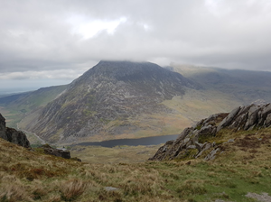
A 61.6km circular trail running route from Staveley village centre / Mill Yard area a serious long-distance mountain trail run from Staveley, taking in big South Lakes climbs, fell tracks and remote-feeling terrain, with around 3,104m of climbing and a highest point of 827m.
61.6km

Distance

3104m

Elevation Gain

11.4 hours to 14.8 hours running / 19.8 to 27.3 hours walking

Estimated Time

Difficulty

Distance Band

Route Map

Details
Ultra Tour of Staveley

About this route

This Ultra Tour of Staveley trail running route is a circular loop from Staveley village centre / Mill Yard area, built from the supplied GPX file and suitable for runners who are comfortable on mixed trail terrain.

The GPX measures approximately 61.6km with around 3,104m of elevation gain and reaches a highest point of about 827m. This is a demanding ultra-distance route for experienced trail runners only. The GPX includes sustained climbing, exposed sections, remote-feeling paths and long periods away from easy facilities.

Use the GPX for navigation, carry appropriate kit for the distance and weather, and always check local access, parking and public transport details before travelling.

Route Features

At a Glance

📍 Start:Staveley

Getting there

Start Point

Staveley
LA8 9LR

Parking

Use public parking in Staveley village or the Mill Yard area where permitted. For a route of this length, check any maximum stay limits and avoid blocking residential streets.

Public Transport

Staveley railway station gives rail access on the Windermere branch line. This is useful for public transport starts, but check early and late train times carefully for an ultra-distance day.

Toilets

Check current public toilet options in Staveley before setting off. Do not rely on facilities once out on the fells.

Nearest Town

Staveley

what3words

What's underfoot

Expect fell paths, mountain trails, bridleways, rocky tracks, moorland, woodland paths, village lanes. The route has approximately 3,104m of climbing over 61.6km, so pace should be adjusted for terrain, weather and navigation.

Best Seasons

Navigation Difficulty

Staveley

Weather Notes

Avoid poor visibility, high winds and heavy rain on exposed or high-level sections. Paths may be slippery, boggy or harder to follow after prolonged wet weather.

Recommended Equipment

Trail shoes are strongly recommended for this route. Here’s what we’d suggest.

Recommended kit for this route

Some links on this page are affiliate links. If you buy through them, Trail Running Planet may earn a small commission at no extra cost to you.

Before, during & after

Water

Carry your own water. Natural water sources should not be relied upon unless treated/filtered, and facilities may be limited or seasonal.

Shops Nearby

Staveley has limited village shopping and food options. Carry all food, emergency calories and water treatment/refill plans needed for a full mountain day.

Post-Run Recommendation

Plan a proper refuel in Staveley after the run. Hawkshead Brewery Beer Hall, Wilf’s Cafe and More Bakery are convenient if open.

How to run it

Route Steps (route_steps repeater)
Replace this widget with a Dynamic.ooo Loop widget connected to the route_steps ACF Repeater field. Each item should show step number, title and description. See build notes for setup.

Follow the well-signed footpath from the car park.
Detailed step description here.

Before you go

⚠ Safety Notes

Follow the GPX closely and carry a map/backup navigation. Conditions can change quickly on open fell, moorland or mountain ground. Take extra care on wet rock, boggy sections, steep descents and road crossings. Let someone know your plan for longer or more remote routes. For this route, carry full mountain running kit, extra layers, food, water, a charged phone and an emergency plan.

🌦 Weather Notes

Avoid poor visibility, high winds and heavy rain on exposed or high-level sections. Paths may be slippery, boggy or harder to follow after prolonged wet weather.

Local knowledge

💡 Local Tip

Start early for quieter trails and easier parking. Check weather and daylight before setting off, especially outside summer. The best experience is usually in a settled dry spell when the views are clear and the paths are less boggy.

🧭 Navigation Difficulty

Frequently Asked Questions

FAQs (route_faqs repeater)
Replace with a Dynamic.ooo Loop widget connected to the route_faqs ACF Repeater field. Fields: faq_question + faq_answer. Add FAQ schema (JSON-LD) in a later phase.

FAQ answer goes here. This accordion will be replaced by the route_faqs ACF Repeater output.
FAQ answer goes here.

Trail Art · Monetisation · Nice to have

Trail Art

Route Trail Poster

A hand-illustrated trail map poster of this route — perfect for your home or as a gift for a fellow runner. Printed on 300gsm card.