Coledale Horseshoe Trail Running Route: 14km Lake District Loop
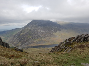
A 13.6km circular trail running route from Braithwaite village / Coledale start area a classic Lake District mountain horseshoe from Braithwaite over the Coledale skyline and high north-western fells, with around 1,157m of climbing and a highest point of 841m.
13.6km
Distance
1157m
Elevation Gain
2.9 hours to 3.8 hours running / 5.2 to 7.1 hours walking
This Coledale Horseshoe trail running route is a circular loop from Braithwaite village / Coledale start area, built from the supplied GPX file and suitable for runners who are comfortable on mixed trail terrain.
The GPX measures approximately 13.6km with around 1,157m of elevation gain and reaches a highest point of about 841m. This is a proper mountain route with steep climbing, rocky ridges and exposed high ground. In clear weather it is one of the best compact horseshoe runs in the northern Lakes.
Use the GPX for navigation, carry appropriate kit for the distance and weather, and always check local access, parking and public transport details before travelling.
Route Features
At a Glance
📍 Start:Braithwaite, Keswick
Getting there
Start Point
Braithwaite, Keswick
CA12 5SY
Parking
Start from Braithwaite village or the Coledale start area. Use signed public parking only, avoid blocking narrow village roads, and expect parking to be limited at busy times.
Public Transport
Braithwaite is close to Keswick, with bus connections in the wider Keswick and Whinlatter area. Check current Lake District bus timetables before travelling.
Toilets
There may not be toilets at the immediate GPX start. Use Keswick or local facilities before travelling, and check current public toilet availability in Braithwaite.
Nearest Town
Keswick
what3words
What's underfoot
Expect mountain paths, rocky ridges, fell paths, scree, steep climbs, moorland, short road sections. The route has approximately 1,157m of climbing over 13.6km, so pace should be adjusted for terrain, weather and navigation.
Best Seasons
Navigation Difficulty
Braithwaite, Keswick
Weather Notes
Avoid poor visibility, high winds and heavy rain on exposed or high-level sections. Paths may be slippery, boggy or harder to follow after prolonged wet weather.
Recommended Equipment
Trail shoes are strongly recommended for this route. Here’s what we’d suggest.
Recommended kit for this route
Some links on this page are affiliate links. If you buy through them, Trail Running Planet may earn a small commission at no extra cost to you.
Carry your own water. Natural water sources should not be relied upon unless treated/filtered, and facilities may be limited or seasonal.
Shops Nearby
Keswick has the best nearby shops, outdoor stores and food options. Braithwaite has pub options close to the route.
Post-Run Recommendation
The Royal Oak or Coledale Inn in Braithwaite are convenient post-run options, with more choice in nearby Keswick.
How to run it
Route Steps (route_steps repeater) Replace this widget with a Dynamic.ooo Loop widget connected to the route_steps ACF Repeater field. Each item should show step number, title and description. See build notes for setup.
Follow the GPX closely and carry a map/backup navigation. Conditions can change quickly on open fell, moorland or mountain ground. Take extra care on wet rock, boggy sections, steep descents and road crossings. Let someone know your plan for longer or more remote routes. For this route, carry full mountain running kit, extra layers, food, water, a charged phone and an emergency plan.
🌦 Weather Notes
Avoid poor visibility, high winds and heavy rain on exposed or high-level sections. Paths may be slippery, boggy or harder to follow after prolonged wet weather.
Local knowledge
💡 Local Tip
Start early for quieter trails and easier parking. Check weather and daylight before setting off, especially outside summer. The best experience is usually in a settled dry spell when the views are clear and the paths are less boggy.
🧭 Navigation Difficulty
Frequently Asked Questions
FAQs (route_faqs repeater) Replace with a Dynamic.ooo Loop widget connected to the route_faqs ACF Repeater field. Fields: faq_question + faq_answer. Add FAQ schema (JSON-LD) in a later phase.