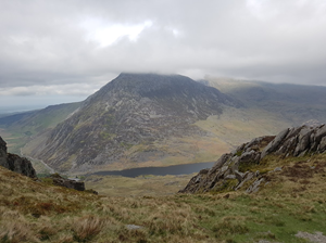
An 8.1km circular trail run from Grassington National Park Visitor Centre through Grass Wood and riverside paths by the River Wharfe, mixing woodland, limestone and classic Wharfedale views.
bit of text here bit of text here bit of text here bit of text here bit of text here bit of text here bit of text here bit of text here bit of text here bit of text here bit of text here bit of text here bit of text here bit of text here bit of text here bit of text here bit of text here bit of text here bit of text here bit of text here bit of text here bit of text here bit of text here bit of text here bit of text here bit of text here bit of text here bit of text here bit of text here bit of text here bit of text here bit of text here bit of text here bit of text here bit of text here bit of text here bit of text here
bit of text here bit of text here bit of text here bit of text here bit of text here bit of text here bit of text here bit of text here bit of text here bit of text here bit of text here bit of text here bit of text here bit of text here bit of text here bit of text here bit of text here bit of text here bit of text here bit of text here bit of text here bit of text here bit of text here bit of text here bit of text here bit of text here bit of text here bit of text here bit of text here bit of text here v
bit of text here bit of text here bit of text here bit of text here bit of text here bit of text here bit of text here bit of text here bit of text here bit of text here bit of text here bit of text here bit of text here bit of text here bit of text here bit of text here bit of text here bit of text here bit of text here bit of text here bit of text here bit of text here
Route Features
At a Glance
📍 Start:Grassington
Getting there
Start Point
Grassington
BD23 5LB
Parking
Start from Grassington National Park Visitor Centre car park on Hebden Road. This is the main National Park car park for Grassington, with pay-and-display parking and EV charging available. Check current charges before travelling.
Public Transport
Grassington is accessible by bus from Skipton, with Skipton also having rail connections. DalesBus/Keighley Bus service 72 links Skipton and Grassington, and other Upper Wharfedale services may be available depending on day and season.
Toilets
Public toilets are available at Grassington National Park Visitor Centre; check opening times and any current charges before travelling.
Nearest Town
Grassington
what3words
///diamond.rewriting.tequila
What's underfoot
Woodland paths, Riverside path, Limestone tracks, Field paths, Short road sections
Best Seasons
Spring, Summer, Autumn, Winter, All year
Navigation Difficulty
Easy
Grassington
Weather Notes
Woodland sections can stay damp after rain and limestone can become slippery. The route is more sheltered than open moorland, but riverside paths may be muddy or wet in poor weather.
Recommended Equipment
Trail shoes are strongly recommended for this route. Here’s what we’d suggest.
Recommended kit for this route
Some links on this page are affiliate links. If you buy through them, Trail Running Planet may earn a small commission at no extra cost to you.
Carry your own water. Food and drink options are available in Grassington before or after the route, but do not rely on water on the trail itself.
Shops Nearby
Grassington village centre has independent shops, cafes and pubs. There is also a Co-op/food shopping option in the village area, useful for snacks before or after the route.
Post-Run Recommendation
Finish with coffee, cake or lunch in Grassington village. The Stripey Badger, Cobblestones Cafe, The Cake House and The Devonshire Hotel are convenient options close to the route start/finish.
How to run it
Route Steps (route_steps repeater) Replace this widget with a Dynamic.ooo Loop widget connected to the route_steps ACF Repeater field. Each item should show step number, title and description. See build notes for setup.
Take care on wet limestone, tree roots and muddy woodland paths. The riverside section may be slippery or wet after heavy rain. Follow the GPX closely where paths cross in Grass Wood and be considerate of walkers, wildlife and livestock.
🌦 Weather Notes
Woodland sections can stay damp after rain and limestone can become slippery. The route is more sheltered than open moorland, but riverside paths may be muddy or wet in poor weather.
Local knowledge
💡 Local Tip
Run early or outside peak visitor times for a quieter experience. Spring is especially good for woodland flowers, while dry autumn days give excellent trail conditions. Allow time after the run for Grassington village cafes and pubs.
🧭 Navigation Difficulty
Easy
Frequently Asked Questions
FAQs (route_faqs repeater) Replace with a Dynamic.ooo Loop widget connected to the route_faqs ACF Repeater field. Fields: faq_question + faq_answer. Add FAQ schema (JSON-LD) in a later phase.