A rewarding 14.3km circular trail running route from Settle, climbing from Whitefriars car park into limestone country around Attermire Scar, open fields and classic Ribblesdale views.
14.3km
Distance
380m
Elevation Gain
1.75 to 2.75 hours running / 3.5 to 4.5 hours walking
This Settle trail running route starts at Whitefriars car park and heads into the limestone country above the town. The GPX is around 14km with approximately 380m of climbing, giving a compact but rewarding Dales loop.
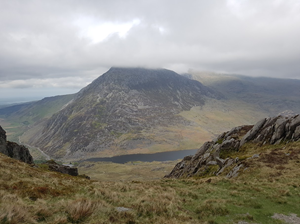
The route is ideal if you want classic limestone scenery without the distance of the Three Peaks. Expect field paths, rocky tracks, open views and a good climb out of Settle before returning to the market town for an easy post-run food stop.
Route Features
At a Glance
📍 Start:Whitefriars car park, 6 Whitefriars Court, Settle
Getting there
Start Point
Whitefriars car park, 6 Whitefriars Court, Settle
BD24 9EA
Parking
Start from Whitefriars car park in Settle. Settle has three main car parks, including Whitefriars, and these are run by North Yorkshire Council. Check current tariffs, time limits and payment options before travelling.
Public Transport
Settle has good public transport access compared with many Dales villages, including rail services on the Settle to Carlisle line and local bus links. The route start is close to the town centre.
Toilets
Public toilets are available at Whitefriars car park in Settle. Visit Settle notes that public toilets in Settle are available at Whitefriars.
Nearest Town
Settle
what3words
What's underfoot
A classic limestone-edge route with a steady climb out of Settle, rocky paths, field tracks, grass, stiles and open views around Attermire Scar. It is very runnable in places, but the limestone can be awkward and slippery when wet.
Best Seasons
Spring, Summer, Autumn
Navigation Difficulty
Moderate
Whitefriars car park, 6 Whitefriars Court, Settle
Weather Notes
Limestone becomes slippery when wet and the higher sections above Settle are more exposed than the town. Low cloud is less common than on the highest fells but can still reduce visibility on the tops.
Recommended Equipment
Trail shoes are strongly recommended for this route. Here’s what we’d suggest.
Recommended kit for this route
Some links on this page are affiliate links. If you buy through them, Trail Running Planet may earn a small commission at no extra cost to you.
Carry water for the route. Settle has shops and cafes before and after, but there are no guaranteed refill points once you leave town.
Shops Nearby
Settle town centre has cafes, pubs, independent shops and food stores close to Whitefriars car park. Castleberg Outdoors are great for all your trail running needs
Post-Run Recommendation
Finish in Settle and use the town centre cafes, bakery options or pubs for food after the run.
How to run it
Route Steps (route_steps repeater) Replace this widget with a Dynamic.ooo Loop widget connected to the route_steps ACF Repeater field. Each item should show step number, title and description. See build notes for setup.
Take care on wet limestone, narrow lanes and field paths with livestock. Carry a map or GPX device and do not rely only on phone signal. Close gates, keep dogs under control and avoid damaging walls or sensitive limestone habitats.
🌦 Weather Notes
Limestone becomes slippery when wet and the higher sections above Settle are more exposed than the town. Low cloud is less common than on the highest fells but can still reduce visibility on the tops.
Local knowledge
💡 Local Tip
This is a strong route for visitors arriving by train because Settle has good rail access and the start is close to town. It is best run on a clear day when the views across Ribblesdale and the limestone scars are at their best.
🧭 Navigation Difficulty
Moderate
Frequently Asked Questions
FAQs (route_faqs repeater) Replace with a Dynamic.ooo Loop widget connected to the route_faqs ACF Repeater field. Fields: faq_question + faq_answer. Add FAQ schema (JSON-LD) in a later phase.