Skipton Moor and Farnhill Pinnacle Trail Running Route: 18km Crag and Canal Loop
A varied 18.1km circular trail run from Skipton High Street Car Park linking Skipton Moor, canal-side running, Farnhill Pinnacle and Craven edge views, with around 412m of climbing.
18.1km
Distance
412m
Elevation Gain
2.25 to 3.25 hours running / 4.5 to 5.5 hours walking
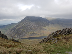
This Skipton Moor and Farnhill Pinnacle trail running route is a varied circular loop from Skipton High Street Car Park. The GPX measures approximately 18.1km with around 412m of ascent, making it a solid local trail run with a mix of runnable sections and hillier ground.
The route links Skipton Moor with the canal corridor and the Farnhill/Kildwick edge, giving a strong mix of town, towpath, fields, moorland and viewpoint running. Farnhill Pinnacle adds a distinctive local landmark and excellent views across Airedale, while Skipton gives an easy start and finish with plenty of post-run options.
Route Features
At a Glance
📍 Start:Skipton High Street Car Park, Jerry Croft, Skipton
Getting there
Start Point
Skipton High Street Car Park, Jerry Croft, Skipton
BD23 1ED
Parking
Start from Skipton High Street Car Park on Jerry Croft, close to Skipton High Street, the canal basin, shops and cafes. Use BD23 1ED for the car park area and check current charges before travelling. It can be busy on market days and weekends.
Public Transport
Skipton has strong public transport links, with Skipton railway station offering rail connections towards Leeds, Bradford, Carlisle and Lancaster, and Skipton bus station serving local Dales routes including Grassington, Malham, Ilkley, Keighley and Settle. The car park is a short walk from the town centre transport hubs.
Toilets
Public toilets are available in Skipton town centre, including facilities around the High Street/Town Hall area. Opening times and charges can change, so check locally before relying on them for early or late starts.
Nearest Town
Skipton
what3words
What's underfoot
A varied Skipton loop with town-centre start, canal towpath, field paths, climbs onto Skipton Moor and the Farnhill/Kildwick edge, plus stony and grassy sections. Expect mud on field paths and slippery stone after rain.
Best Seasons
All year
Navigation Difficulty
Easy
Skipton High Street Car Park, Jerry Croft, Skipton
Weather Notes
The moor and pinnacle sections are exposed in wind and rain. Canal and town sections are easier to follow, but field paths and stone can be muddy or slick after wet weather.
Recommended Equipment
Trail shoes are strongly recommended for this route. Here’s what we’d suggest.
Recommended kit for this route
Some links on this page are affiliate links. If you buy through them, Trail Running Planet may earn a small commission at no extra cost to you.
Carry water from the start. Shops and cafes are available in Skipton, and there may be options in Farnhill/Kildwick depending on the exact line and opening times, but do not rely on them.
Shops Nearby
Skipton High Street has supermarkets, bakeries, cafes, outdoor shops and independent retailers. The canal basin and town centre are useful for snacks, water and post-run food.
Post-Run Recommendation
Finish in Skipton and use the High Street or canal basin for coffee, food or a drink. The route works well as a half-day run with a relaxed post-run stop in town.
How to run it
Route Steps (route_steps repeater) Replace this widget with a Dynamic.ooo Loop widget connected to the route_steps ACF Repeater field. Each item should show step number, title and description. See build notes for setup.
The moor and pinnacle sections are exposed in wind and rain. Canal and town sections are easier to follow, but field paths and stone can be muddy or slick after wet weather.
Local knowledge
💡 Local Tip
🧭 Navigation Difficulty
Easy
Frequently Asked Questions
FAQs (route_faqs repeater) Replace with a Dynamic.ooo Loop widget connected to the route_faqs ACF Repeater field. Fields: faq_question + faq_answer. Add FAQ schema (JSON-LD) in a later phase.