Wharfedale Three Peaks Trail Running Route: 27km from Kettlewell
A challenging 26.8km circular fell running route from Kettlewell National Park car park, linking Upper Wharfedale climbs, open moorland and big views around the Wharfedale Three Peaks area.
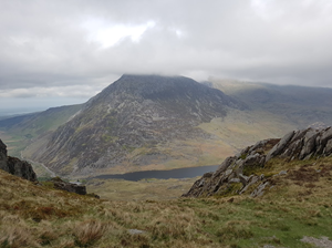
This Wharfedale Three Peaks trail running route is a hard circular fell run from Kettlewell in Upper Wharfedale. The GPX is around 27km with over 1,100m of climbing, making it a shorter but still serious alternative to longer Dales challenge routes.
Expect steep grassy climbs, open moorland, boggy sections and exposed high ground. The route rewards strong runners with big views over Wharfedale and a proper fell-running feel from the village start.
Route Features
At a Glance
📍 Start:Kettlewell National Park car park, Kettlewell, Skipton
Getting there
Start Point
Kettlewell National Park car park, Kettlewell, Skipton
BD23 5QZ
Parking
Start from Kettlewell National Park car park in the centre of the village. This is a pay and display National Park car park and charges apply. Spaces can fill on weekends and holidays, especially in good weather. Grid ref: SD 9676 7233.
Public Transport
Kettlewell is served by Upper Wharfedale bus services linking Skipton, Grassington, Kettlewell and Buckden. Check DalesBus and North Yorkshire timetables before travelling, especially on Sundays, bank holidays and winter dates.
Toilets
Public toilets are available at Kettlewell National Park car park, including accessible/RADAR facilities. There are no reliable toilet facilities on the open fell sections.
Nearest Town
Kettlewell
what3words
repeated.advantage.grudges
What's underfoot
A compact but serious Wharfedale fell route with steep climbs, rough grass, boggy moorland, exposed summit sections and fast descents back towards the valley. The distance is much shorter than the longer Kettlewell loop, but the terrain is still committing.
Best Seasons
Spring, Summer, Autumn
Navigation Difficulty
Moderate
Kettlewell National Park car park, Kettlewell, Skipton
Weather Notes
Upper Wharfedale fell weather can change quickly. Low cloud can make the moorland confusing, and wind or rain can make the exposed high points feel cold even in summer.
Recommended Equipment
Trail shoes are strongly recommended for this route. Here’s what we’d suggest.
Recommended kit for this route
Some links on this page are affiliate links. If you buy through them, Trail Running Planet may earn a small commission at no extra cost to you.
Carry enough water for the full route. Natural sources on the fell should be treated and may be unreliable in dry weather. Kettlewell is the main practical refill point.
Shops Nearby
Kettlewell has pubs, cafes and a village shop. Grassington and Skipton offer more extensive shops and services before or after the route.
Post-Run Recommendation
Finish in Kettlewell and use one of the village pubs or cafes for food and drinks. Grassington is a good backup if you want more choice after the run.
How to run it
Route Steps (route_steps repeater) Replace this widget with a Dynamic.ooo Loop widget connected to the route_steps ACF Repeater field. Each item should show step number, title and description. See build notes for setup.
Carry full hill kit, including waterproofs, warm layer, map, compass, charged phone, backup navigation, food and water. The route crosses exposed moorland where navigation can be difficult in cloud. Avoid in poor weather unless experienced.
🌦 Weather Notes
Upper Wharfedale fell weather can change quickly. Low cloud can make the moorland confusing, and wind or rain can make the exposed high points feel cold even in summer.
Local knowledge
💡 Local Tip
This is a good option when you want a hard Wharfedale day without committing to the longer 40km-plus route. Start early, especially in summer, and leave time for a relaxed food stop in Kettlewell afterwards.
🧭 Navigation Difficulty
Moderate
Frequently Asked Questions
FAQs (route_faqs repeater) Replace with a Dynamic.ooo Loop widget connected to the route_faqs ACF Repeater field. Fields: faq_question + faq_answer. Add FAQ schema (JSON-LD) in a later phase.