Yorkshire Three Peaks Extended Trail Running Route: 43km from Horton-in-Ribblesdale
A tough 43.2km circular trail running route from Horton-in-Ribblesdale taking on an extended Yorkshire Three Peaks taking in the standard Pen-y-ghent, Whernside, Ingleborough and including Plover Hill with big limestone scenery and sustained climbing.
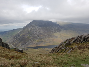
For when 3 peaks just isn’t enough. This extended Yorkshire Three Peaks trail running route starts in Horton-in-Ribblesdale and follows a demanding circular line through classic Ribblesdale limestone country. The GPX comes out at around 43km with over 1,600m of climbing, so this is a full mountain day rather than a casual trail run.
The route takes in the iconic Three Peaks landscape of Pen-y-ghent, Whernside and Ingleborough, with long runnable sections broken up by steep climbs, rough ground and exposed summit terrain. It is best suited to experienced trail runners with strong navigation and hill fitness.
Start from Horton-in-Ribblesdale National Park car park beside the B6479/Pennine Way. This is a pay and display National Park car park with charges applying. It can fill very early on weekends and challenge-event days, so arrive early and park responsibly in marked spaces only. Grid ref: SD 807 725.
Public Transport
Horton-in-Ribblesdale is on the Settle to Carlisle railway line, making this one of the better Yorkshire Dales long routes for public transport. Check current train times before travelling and do not assume late return options after a full Three Peaks day.
Toilets
Public toilets are available at Horton-in-Ribblesdale National Park car park and are useful before starting. Do not rely on toilet facilities once committed to the route.
Nearest Town
Settle
what3words
florists.famines.exhaled
What's underfoot
A serious long-distance fell and limestone route with steep climbs, rocky descents, exposed moorland, grassy trods, stone flagged sections and some short road or lane links. The route is runnable in places but slow and technical across the high ground and limestone sections.
Best Seasons
Spring, Summer, Autumn
Navigation Difficulty
Easy
Horton-in-Ribblesdale, Grid Reference SD 807 725
Weather Notes
The Three Peaks create their own weather. Expect wind, low cloud and fast-changing conditions on the summits even if Horton is calm. Wet limestone and stone flags can be slippery, and winter conditions make this a much more serious outing.
Recommended Equipment
Trail shoes are strongly recommended for this route. Here’s what we’d suggest.
Recommended kit for this route
Some links on this page are affiliate links. If you buy through them, Trail Running Planet may earn a small commission at no extra cost to you.
Carry enough water for the full route. Refill options are limited and opening times vary, so do not rely on cafes or pubs being open. Treat any natural water before drinking.
Shops Nearby
Small village facilities in Horton-in-Ribblesdale are limited. Settle has more shops, cafes and supermarkets for supplies before or after the run.
Post-Run Recommendation
Small village facilities in Horton-in-Ribblesdale are limited. Settle has more shops, cafes and supermarkets for supplies before or after the run.
How to run it
Route Steps (route_steps repeater) Replace this widget with a Dynamic.ooo Loop widget connected to the route_steps ACF Repeater field. Each item should show step number, title and description. See build notes for setup.
The Three Peaks create their own weather. Expect wind, low cloud and fast-changing conditions on the summits even if Horton is calm. Wet limestone and stone flags can be slippery, and winter conditions make this a much more serious outing.
Local knowledge
💡 Local Tip
🧭 Navigation Difficulty
Easy
Frequently Asked Questions
FAQs (route_faqs repeater) Replace with a Dynamic.ooo Loop widget connected to the route_faqs ACF Repeater field. Fields: faq_question + faq_answer. Add FAQ schema (JSON-LD) in a later phase.